
In mid-August 2018, people in far-flung villages of Kodagu – a district of 554,000 in Karnataka – reported hearing a sound they described as the explosion of a bomb or a cloud burst, perhaps the rumble of an earthquake – like earth's anger, something bursting at its seams. None of these had ever occurred in the district before; all people had for the analogies were things they had read or seen in news from elsewhere. The consensus, however, was that it was a sound that they would never be able to properly describe. What happened in those hours between 15 and 18 August, would wipe entire villages off the map, give birth to new rivers, change courses of old rivers, obliterate land and hearths, and mark lives forever.
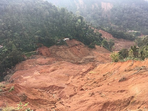
Around the time that national and global attention was turning towards the unprecedented devastation caused by floods in Kerala in southern India, across the border in neighbouring Kodagu, traditionally known as coffee country, it started raining very heavily. Situated in the eastern slopes of the Western Ghats – a mountain range that is a UNESCO World Heritage Site and one of the most biodiverse spots in the world – Kodagu sees heavy rains during the monsoon. But this year, after drought-like conditions for three preceding years, the rains lashed and left behind a frightening trail of destruction the likes of which no one in the district had heard of or seen in living memory. The loud boom that people heard was the sound of mountains caving in, of landslips along stretches up to seven kilometres long that buried entire villages under earth, and of rivers that gushed out from below the surface of what once used to be flat coffee plantations, sweeping away people, animals, houses and futures.
The inventory of ruin soon began to grow long. Mountains were slipping down and their debris was covering paddy fields. Sinkholes in connecting roads made nearly every town and village an island onto itself. Villages like Makkanduru, Thantipala, Kadamakallu and others, which were rarely heard of even within Kodagu, became more and more familiar on people's tongues even as they were being wiped out of existence. The highway to Mangaluru – an important road for not just people movement, but also for bringing fuel and vegetables into the district – caved in for several kilometres, and there were rivers flowing over what used to be road. The thick mist that covers these northern parts made it impossible for rescue operations to always succeed, and often people ended up braving the fragile earth and walking tens of kilometers to reach relief camps set up in larger towns.
While the stocktaking of the overall loss continues, according to an estimate by the state government, the quantifiable damages were as follows: at least 20 dead, many still missing or presumed dead, around 2000 km of damaged roads, 1200 destroyed homes, 240 collapsed bridges, INR 3435 crores (USD 465 million) in losses, and 9000 hectares of ruined crops. Some have lost entire estates and homes, and with it, generations worth of personal history. Given the loss of top soil in many areas due to landslides, it might take several years – as many as 30, according to the former chairperson of the Coorg Planters' Association – before these areas can be fertile enough for future cultivation.